Community header template

- Home
arrow_drop_down
- News
arrow_drop_down
- What’s On
- Local Information
arrow_drop_down
- Community Groups
arrow_drop_down
- Business Support
arrow_drop_down
- Advertising Rates
- Business Networks
- Akin Arundel
- Arundel Chamber of Commerce
- Consultants, Admin Support & Office Space
- Film Location & Production Support
- IT & Technical Support
- Legal, Financial Planning, Accountants And Insurance
- Local Publications And Media
- Marketing, Printing & Digital
- Business Newsletter
- Local Directory
arrow_drop_down
- Estate & Lettings Agents & Architects
- Health, Beauty & Wellbeing
- Home & Gardening Services
- Legal, Financial Planning, Accountants And Insurance
- Photographers, Fashion & Lifestyle
- Retirement, Care & Funeral Services
- Travel, Holidays & Languages
- Tradesman, Builders and Property Services
- Vehicle Repairs, Storage, Hire & Taxi Services
- Weddings, Events & Entertainment
- Contact
Just six years after the first Arundel Neighbourhood Plan, a detailed review was submitted and approved. Why, and why does it matter?
The idea of linking ‘neighbourhood’ to urban planning dates back to 1915 when a Mr Robert E. Park and a Mr E. W. Burgess introduced the idea that ‘neighbours’, the people who live and work in an area, could have ideas, and should have an input, into the development of the built world around them.
A chance to have your say...


Power to the people
Fast forward to April 2012, and David Cameron decided that sounded like a mighty fine idea. Cue the Localism Act and the launch of his ‘Big Society’ to devolve power to local government and to give communities a stronger voice.
Government wanted people to be able to: “choose where (you) want new homes, shops and offices to be built, have (your) say on what… they should look like ”
Arundel was quick to take up Mr Cameron’s challenge. In 2014, Arundel delivered its first Neighbourhood Plan for the period from 2014-2029, with a stated aim to make: “a good place better, building on good things, using brownfield sites rather than releasing greenfield, promoting sustainable travel and protecting the town from further flood risks.”
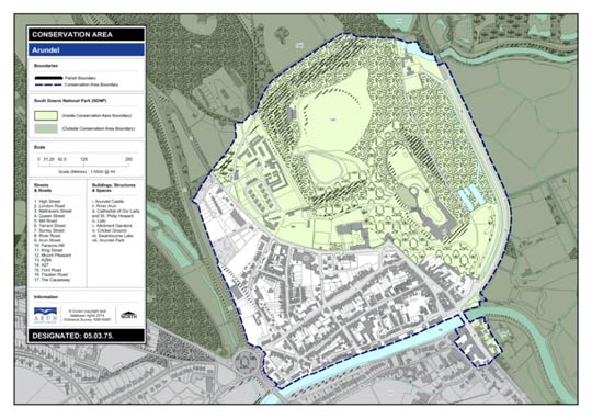
The redevelopment of the Bevin & Bevin brewery site, between Tarrant Street and River Road, emerged from this first process along with several other site schemes yet to be started (including the former Gas Works site on Ford Road, Castle Stables and the Blastreat/Greenhurst site on Fitzalan Road). You can read more about the 2014 plan here: https://www.arun.gov.uk/arundel-neighbourhood-development-plan/.
However, in 2018, those involved in drawing up that first plan felt a review was needed because:
- Arun District Local Plan developments meant double the number of new homes would be required by 2031.
- Neighbourhood Plans’ legal framework had changed. Parts of the 2014 ANP needed updating and strengthening.
- Which is why, four years after Arundel’s first Neighbourhood Plan, let’s call it ANP1 (because, that’s its name), ANP2 was started.
Who worked on ANP2?
Arundel representatives and residents including some who had steered ANP1 shared their experience and knowledge of the process to build on what had been achieved with ANP1. Former mayor, and previous ANP chair, James Stewart agreed to run ANP2.
The ANP2 Steering Group welcomed representatives from across Arundel, including schools, churches, residents, businesses, Town Council and attractions.
The aims of ANP2
“We know why many people choose to live in, work in and visit Arundel,” says James Stewart. “Arundel’s key strengths are the community spirit, its location on the Downs, straddling the river Arun and close to the sea and finally its heritage mixed with contemporary culture.
“However, it is easy to see the town through ‘rose tinted’ glasses, to only see the positives and thus not appreciate the need for change,” says James Stewart.
As part of the consultation process, three working groups were set up to find out what Arundel folk want. These groups were drawn from three areas of town: Torton Hill (South of A27), Town Centre (largely the Old Town conservation area) and Riverside (River Road & Fitzalan Road).
Each group was asked, over three meetings, to delve into four subjects; social infrastructure, connectivity, economy, housing.
“The workshops and focus groups underlined what we already knew,” explains James Stewart. “There are areas which can be improved upon. Parking, a shortage of affordable housing, and a concern that Arundel is no longer the important market town it was.”
Why can Neighbourhood Plans cause controversy?
Whether it’s the evening view from your flat or open land behind your house or business, preserving and protecting the space around us matters. Any development is therefore a balancing act between competing views.
Throughout the ANP2 process, the steering groups asked residents for their views to create a plan that provides the new homes required within the physical constraints on Arundel (flood zones and available land).
A significant, vocal majority campaigned against the ANP2, but at referendum, with a turnout of 35%, 80% supported the plan.
If Neighbourhood Plans mean ‘power to the people’ does that include affordable homes?
It certainly does in Arundel! A 2012 Housing Needs Survey highlighted the need for more affordable housing in Arundel. These findings fed into ANP1 and were updated by Arundel Town Council in 2020.
‘Affordable’ rent is defined, by the National Planning Policy Framework (NPPF), as no more than 80% of market rates. ANP2 went further, with the objective to provide ‘truly’ affordable housing at ‘social rent’, which is 50%-60% of market rates, and a small number of shared ownership homes.
This is part of the plan for the Ford Road development, and to ensure this happens, the ANP2 steering group is working closely with the former Gas Work site owner.
The Arundel Community Land Trust (CLT) has also been set up to make sure more affordable housing becomes a reality, with priority given to those with existing links to town. You can read more about the Arundel CLT here.
What was agreed in ANP2?
The ANP2’s vision statement, key objectives and land use policies can run from 2018 to 2031.
Main housing policies include:
- Ford Road site, the upper part of the field between the built-up area and Priory Lane behind Dalloway Road, for 90 homes (27 affordable) plus land for a community building and links to the footpath network
- Blastreat/Greenhurst for 26 dwellings
- Police Station site on The Causeway for 12 dwellings
Other polices include:
- Protection of non-designated heritage assets and community facilities
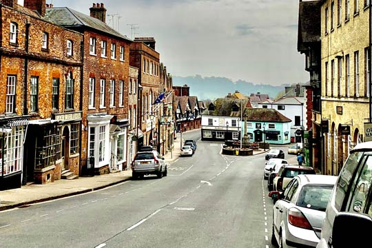
- Strengthening Town Centre as a vital, vibrant heritage, culture, leisure, specialist shopping/eating) centre for both residents and visitors.
- A ‘Green Infrastructure’ network, to join up green spaces, points of interest and public rights of way, e.g. Canada Gardens to Arundel Station
- Canada Gardens protected as a ‘Local Green Space’, as for Horses Field, Canada Road play area & Herrington Field in ANP1
Policies from ANP1 that still apply include:
- Housing allocations at Castle Stables and Ford Road Gas Works site
- Promotion of walking, cycling and public transport use
- Parking management strategy
- Support community and culture use of The Victoria Institute
- Support Project LEAP at Arundel Lido
- Mill House Farm Barn to be repaired and reused
- Protect/enhance assets of community value
- Flood defences protection
- Protect Buildings and Structures of Character, e.g the War Memorial
Do we have to create a Neighbourhood Plan?
No, not by law. There is no legal requirement for communities in England to submit one, however, not having a neighbourhood plan leaves communities vulnerable to unwanted development.
Under the Arun District Council (ADC) local plan, thousands of new homes are needed every year for the next 20 years.
Within this plan, large ‘strategic sites’ (500 or more homes) are detailed. However, ‘non-strategic site’ developments in parishes outside main towns are not specifically covered.
This means that without an Arundel Neighbourhood Plan, ADC will decide on housing plan applications.
With ANP2 in place, ADC planning inspectors can use Arundel’s plan when making decisions, providing greater protection for Arundel. This was seen when the planning inspector stated that ANP2 was a deciding factor in the decision to refuse development of 47 retirement flats on the Blastreat/Greenhurst site.
You can find out more about Neighbourhood Plans here: www.gov.uk/guidance/neighbourhood-planning–2
Where can I find out more about the ANP2?
www.arun.gov.uk/arundel-neighbourhood-development-plan-2
For more detailed information, you can also read:
- The Site Assessments Report, for all sites submitted by landowners for development.
- The Consultation Report, for an overview of community consultations.
- The Sustainability Appraisal Report, which looks at biodiversity, flood risk and protection of heritage assets.
- The Examiner’s Report, for his work and decision that Submission NP (ANP2) should proceed to referendum.
Details of ANP2 are also available on the SDNPA website.
The latest news from the Neighbourhood plan
Heading two
Jul
24
SALES SUITE OPENS AT LUXURY NEW DEVELOPMENT ‘ARUNDEL GATE’ LOCATED ON FORD ROAD
Arundel Gate Award-winning property developer Esquire Developments proudly opens the…
Jun
17
Arundel Festival of the Arts 2024
Photography by Charlie Waring Written by Barb Hogan What is the Arundel Festival of…
Jun
13
Welcome and Deserved Success For The Arundel Pharmacy
Welcome and Deserved Success For The Arundel Pharmacy Your may remember that in…